Wednesday, August 17, 2016

Pokémon GO and Public Space

 Pokémon GO players gather at Peg Patterson Park in Rhodes, Sydney. Source: ABC

In an earlier post here, I argued that Pokémon GO involves players in a form of 'playbour', because playing the game involves the production of geospatial data that is owned and can be traded by the game's creator, Niantic.

In this post, I want to take a look at a related set of issues that have arisen with the rapid and massive popularity of this game. If Pokémon GO has figured out a way to encourage and then profit from our explorations of public space, what else does the game have to teach us about public space in our digitally 'augmented' urban playgrounds?

**

Pokémon GO is an 'augmented reality' app, and is by far the most popular application of this technology that we've seen. 'Augmented reality' (AR) makes use of internet connectivity, location awareness and cameras on smartphones to allow people to view digital images and information that have been layered onto the 'real' physical environment.

A few years ago, AR was going to be the next big thing in digital tech. But things didn't quite go as predicted, and more recently, we started seeing more and more commentary on the failure of AR to live up to that hype. Now, with the massive popularity of Pokémon GO, it seems to be back with a bullet.

At least three fascinating issues concerning Pokémon GO and public space have arisen in the past few weeks, and I think they illustrate some broader issues that are pertinent for discussions of augmented reality in urban environments.

1. Where are the Pokémon? On the uneven distribution of digital 'augmentation' across public spaces

So, are there Pokémon in your neighbourhood? Of course, as the game is rolled out across different markets at different times, this will depend in the first instance on whether or not the game has come to your country! (Africa, you're still waiting! You too, India and China. CNET are keeping an updated list of countries where you can (officially) play the game here.)

But even if the game is available in your city, we are seeing that some neighbourhoods are full of Pokémon and PokéStops, while in other places there are less to find.

This interesting article from the US by Christopher Huffaker makes some very interesting observations about the locations of key sites or 'portals' in an augmented reality game called Ingress. This matters for our discussion because Ingress is a predecessor to Pokémon GO, was developed by the same operator (Niantic), and its geospatial data has been used to set locations for key sites in Pokemon GO like PokéStops and Gyms. Huffaker argues there are fewer portals in predominantly African-American neighbourhoods of large US cities like Detroit, New York and Chicago. Researchers at the Urban Institute in Washington DC have done their own maps, and have come to similar conclusions.

Now, no-one is suggesting that a group of nasty people working for Niantic sat down and plotted out an uneven, racialised distribution of Pokémon GO sites to make it harder to play in predominantly African-American neighbourhoods. But that's the whole point. When crowds are used to source data, the data is only as inclusive as the crowd. And because Ingress tends to be played by a quite specific kinds of people, Pokémon data reflects those demographics.

More broadly, we might also observe that when algorithms are used to turn such data in geospatial information, the data is only as inclusive as the parameters that have been coded for the algorithms. The algorithmic nature of the game information is also most likely the explanation for the various stories appearing about 'inappropriate' game locations, like memorials and some secure sites -- not to mention suburban parks that might not have the infrastructure to cope with hoards of people trying to hang out there (more on that one below).

For most of us, it's very difficult to get a grip on the way such algorithms work. Even if we could get corporations or governments to share their code, those lines of code only make sense to those with the specialist skills to understand how they work. There's a growing literature on the role of algorithms in the governance of cities and populations. That literature suggests that as algorithms become ever more important in informing and even automating decision-making and resource allocation, we might want to know a little more about how they work, and how their injustices can be made visible and contested. The discussion about the location of key sites in Pokémon GO certainly illustrates the kinds of things that are at stake.

There are two more points to note about the location of important sites in the game. First, the geography of the game is likely to change as more sponsorship deals are done between Niantic and those seeking to lure players to their location. As has been widely reported, the first of these major deals was done with McDonalds in Japan, and many more are set to follow - Niantic's John Hanke says that this is his preferred means of raising revenue. Shops and advertisers can also spend money to buy and then set lures for players. So, for all the hype about the way that this game is encouraging people to explore their urban environment, we might want to ask some questions about how those explorations are being guided as the digital geography of the game is further commercialised.

Second, a conflict has emerged between Niantic and a numbers of fan websites that had been providing real-time maps of Pokémon locations, by scraping data from the game. As reported by CNET and others, it appears that Niantic have found a way to prevent tracking sites like Pokevision accessing their locational data, and made a few legal threats to those sites while they are at it. The operators of Pokevision wrote an open letter to Hanke and Niantic about the shut down. Hanke and Niantic responded with a blog post claiming that they'd taken the action to reduce pressure on their servers, which have been melting down frequently. This conflict over the openness of the game's location data is an interesting one. This is a game operated by a commercial gaming company, so to what extent do the usual arguments about 'open data' apply? Interestingly, those running the tracking sites are arguing that their access should be maintained because it will enhance the playability of the game, especially while the tracking feature continues to have problems. This interesting conflict is to be continued, I'm sure...

2. Who can access the Pokémon? On uneven access to public space in cities of inequality

Not everyone who walks around a city staring at their phone searching for Pokémon will have the same experience of this 'play'. To play this game is to walk around an urban environment in search of Pokémon, PokéStops and Gyms. Indeed, the game also rewards you for the steps you take while playing it, with those steps helping you to hatch eggs. (A brilliant way to ensure that your geographical data can be captured, by the way ... but that's another story.)

Niantic and the game's supporters are talking up the social and the health benefits of this kind of play -- if millions of people are now out and about in their public spaces, exploring places they have never been, meeting other players and getting exercise at the same time, then everyone wins, right?

Well, sort of. Here's where Pokémon GO interacts with the broader politics of public space. As we know from decades of research on this topic, public spaces in our cities are not equally accessible to everyone.

Again in the United States, there has been some critical discussion about the experience of 'Pokémoning While Black'. In Iowa City, Faith Joseph Ekakite shared this account of being stopped and searched at gunpoint by police while playing the game in a park. Omari Akil wrote this widely-reported account of his unease while playing the game, fearing that Pokémon GO could be a death sentence for black men, given the on-going problem of police shootings in the US.

Not surprisingly, there has also been some discussion of the potential vulnerability of children playing the game, and the potential for them to be 'lured' to locations where they might be targeted for their smartphone or something else. Here,

There seems to have been less discussion of the gendered politics of playing Pokémon in public space. A recent report suggests that female players outnumber male players by a ratio of almost 2 to 1. If that's true, I'll admit that it challenges my own assumptions about the gendered nature of both gaming and public space.

In fact, this finding raises the question of whether Pokémon GO game play might actually help to address, rather than reinforce, some of the exclusionary aspects of public space that I've mentioned above. Anecdotally, some people playing the game tell me that it has given them and their friends a kind of 'license' to be in various places that they would not normally go, like parks and residential streets late at night. They say they can do so because they know there will be other people around also playing, and so places will be less scary than they might otherwise have been. Are the eyes on the screen are also 'eyes on the street', in a Jane Jacobs kinda way? Will this actually help to make public spaces more accessible, by being more used?

3. Whose infrastructure supports the game? On the public-private relationship in augmented urban spaces

Niantic provides the digital data and server infrastructure that enables people to play the game as they move around their environment. But as Pokémon GO turns the streets and parks and malls of the city into a playground, who provides the playground? The game takes-for-granted the existence of 'physical' public spaces and their infrastructures, and makes no particular contribution to their provision or maintenance.

On the surface, this doesn't seem unreasonable -- after all, public space is notionally meant to be accessible to all, right? So why shouldn't it be available for play (or playbour)?

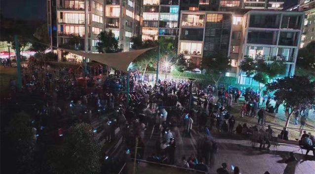
However, it's clear that in some instances, the popularity of the game has actually put some public spaces under considerable pressure. Here in Sydney, an everyday park in suburban Rhodes that most people had never visited or even heard of was inundated with hundreds (perhaps thousands) of Pokémon GO players in search of rare Pokémon that were concentrated in the area. Word of the bounty on offer in the park spread quickly through social media, so this was a classic example of a nimble, digitally-connected crowd in formation and action.

Residents complained of noise and litter. At one point, they took to throwing water bombs from their balconies late at night to try to clear the park. Police were called, and they issued parking infringements to try to move people on.

As several players pointed out, there were no fights, no violence, no crime, and this is meant to be public space ... so what's the problem?

But it's also true that the crowds had some impacts on the park. The picture below accompanied an article on one local website about the issue -- the park does seem kinda messed up.


While maintaining local parks is one of the responsibilities of public authorities, and while those parks are there to be used by 'the public', this little episode demonstrates some of the complex geographical dimensions of urban publicness

I think we do need to resist the idea that this park somehow 'belongs' to the 'local' public, and the associated logic that people coming from 'elsewhere' is a problem in itself. Nor would I want to see any kind of 'users pays' logic be introduced to park use in Sydney, or elsewhere.

But what of the private commercial entities who are making lots of money, but who are not actually making any contribution to support the urban environment that supports their game? Yes, there is socialisation going on here, but there is also commercialisation (something can be two things at once!). And where there's commercialisation, it's not necessarily unreasonable for the public authorities to seek some kind of contribution or compensation. Money for growing trees doesn't grow on trees, if you know what I mean.

Earlier this year, Evgeny Morozov made the case in a piece for the Guardian that the tax-dodging and tax-minimising practices of huge digital corporates like Uber and Google was actually contributing to the hollowing out of state capacity to fund public services like transport. It's a question worth asking: while Pokémon GO might be enhancing some people's experience of public space, but should we expect some financial contribution from the game's owners to sustaining the playground for their very profitable game?

**

So, there you go. Across these three sets of issues, we can see that the game's popularity throws up some new questions about public space in networked cities, but also draws us into some very old questions about the city's streets and their accessibility. It's only a game, I know. But as our experience of public space is increasingly mediated through digital connectivity, it's a game that does have something to teach us about how the urban experience is being transformed through collisions of the digital and the urban.

In finally finishing this piece, I've also come across a few other interesting articles specifically on the issue of Pokémon GO and public space that are worth checking out:

Sunday, August 7, 2016

Pokémon GO and 'digital labour' in the augmented city

So ... Pokémon GO has been a thing, right?!

The article below was published as an opinion piece in the Sydney Morning Herald last week. It's included here with active links for anyone who's interested. It's about the way the game turns play into a kind of 'digital labour', through the collection and monetisation of data about our movements through the urban environment.

I've got a bit more to say about the game ... I really do think it has plenty to teach us about the on-going digitalisation of everyday urban life. More to follow soon.


**

As Pokémon GO maintains its place at the top of the app charts, and as our streets and parks are increasingly populated by screen-illuminated trainers trying to find and evolve their digital critters, it’s time to ask a few questions about the kind of ‘play’ that is going on here.

For many, this this game is great fun. And it is free to download. But Niantic (the game’s creator, a spin-off company from Google), Google, Nintendo and others have invested cold hard cash in developing the game and trying to maintain the infrastructure that supports it. A closer look at how the app might provide some return on that investment tells us something important about the nature of ‘free play’ in our digitally-augmented urban playground.

How does Pokémon GO make money for its creator and investors? Of course, as with many free apps, there are ‘in-app purchases’ that will be attractive to some (if not all) players. Some analysts estimate earnings of over $1 million per day from such purchases. These in-app purchases are the most visible form of revenue from the game, but they are by no means the only or even the most lucrative revenue source.

At present, the real-world location of most important places for players like PokéStops and Gyms have been set by Niantic – based on spatial data acquired from another of their augmented reality games, Ingress. In that game, retailers and others can pay Niantic to have portals located in or near their premises. This has now occurred with Pokémon GO in Japan, where McDonalds has become the first company to do a deal with Niantic to sponsor Gym locations. Such deals are expected to occur elsewhere very soon.

But the revenue potential does not stop there. As the saying goes, “surveillance is the business model of the internet”. Augmented reality games like Ingress and Pokémon GO have the potential open up a very lucrative new revenue stream based on the acquisition and sale of data – not just personal data, but aggregated spatial data about urban activity patterns.

There has already been some controversy about the terms of service for players, which give Niantic access to all manner of data on their phones – including email contacts and social media profiles. This data could potentially be sold to third parties with an interest in targeted advertising. Concerns about this arrangement resulted in a modification of those initial terms of service – but this modification has not satisfied the likes of Senator Al Franken in the United States or consumer advocates in Germany, both of whom have raised on-going concerns with Niantic.

But it is not only individually-identifiable personal data that interests Niantic. They are also interested in the spatial data that is generated by Pokémon GO players. As has been widely observed, playing the game rapidly drains phone batteries, because when the game is open your phone is constantly in touch with Niantic servers and providing detailed spatial information about your movements. The Privacy Policy notifies players that locational data will be collected during game play, and that “We may share aggregated information and non-identifying information with third parties for research and analysis, demographic profiling, and other similar purposes”. It goes on to note that “Information that we collect from our users is considered to be a business asset”.

This not only has the potential for surveillance of an individual gamer’s movements through the city (a potential which is of course inherent in smartphones anyway). Aggregated data about players’ movements through the city also has the potential to be incredibly lucrative.

Niantic is now harvesting geospatial data about millions of people’s routes from one place to another, about how far they are prepared to travel as part of game play, about the kinds of places they stop during game play, about the groups they travel with and the connections they make during game play, and much more besides.

The commercial potential of such information is huge. These markets for personal and geospatial data are closely guarded, and notoriously difficult to track by interested observers. While Niantic CEO John Hanke has remained tight-lipped in response to questions about the game’s revenue model, the collection and ‘sharing’ of such data is undoubtedly a core part of the business model of the app.

So, even gamers who never spend a cent on in-app purchases or promotions are effectively producing information that becomes a commodity owned by Niantic. The free distribution of Pokémon GO can be likened to the free distribution of a tool that lets us make stuff that then belongs to someone else.


Of course, this tool happens to be pretty fun to use. But this should not distract us completely from what’s at stake here. Work might be fun. But that doesn’t make it any less a form of labour. And as our everyday urban lives are increasingly commodified in this way, it’s time to start seeking answers to serious questions about how the spoils of our labour (or ‘playbour’) are collected and distributed.

Thursday, March 19, 2015

Just because you've got nothing to hide, doesn't mean you've got nothing to lose...

Trust us, we're the good guys ... and there are bad guys, so we need your metadata. ASIO Chief David Irvine and Australian Federal Police Deputy Commissioner at a press conference supporting metadata retention laws. Source: News Corp 

This week, the Australian House of Representatives passed new laws which extend the Government’s surveillance powers, by requiring telecommunications companies to store our metadata for two years, and to make this metadata available to government security agencies without a warrant. (Unless you’re a  journalist, in which case an amendment has been proposed to require a warrant.)

While much of the political debate has focused on the important question of whether journalists will be in a position to protect their sources if the legislation passes, there are broader issues at stake.
In defending the legislation, people like the AFP Commissioner and Attorney-General have frequently invoked the ‘nothing to hide’ argument. Any argument against the Bill is met with the assertion that if you’ve got nothing to hide, then you have nothing to fear from governance agencies having access to your metadata. By extension, advocates of the Bill suggest that the only people who have something to fear from increased government access to their metadata are the anti-social, the criminal, and the terrorist.

The forced storage and sharing of metadata is but the latest incidence of surveillance creep in Australian society. Just as our movements and connections in cyberspace are tracked, so too are our movements through physical space – by CCTV cameras, licence plate recognition systems, commercial wi-fi providers, transport smart card systems, and many more technologies besides. As with the metadata laws, the ‘nothing to hide’ argument is frequently invoked to sure up support for all of these technologies.  

The ‘nothing to hide’ argument is mobilised so often by surveillance advocates because it does have traction in the wider community. When I discuss this issue with university students, for instance, the ‘nothing to hide’ argument is frequently used as a way of rationalising everything from participation in social media to support for (or at least indifference towards) increased surveillance by both corporations and state authorities.

When the issue of privacy is put this way, it is probably no surprise that many people choose to identify with the ‘nothing to hide’ argument. After all, if your choice is between having ‘nothing to hide’ and being a criminal or a terrorist, that’s not much of a choice at all for most people. And besides (so the argument goes), any loss of individual privacy is a small price to pay for the convenience and security provided by new communications and surveillance technologies. Indeed, as Prime Minister Abbott has put it, the good citizen may have to give up some personal privacy for the collective good of national security in these ‘troubled times’.


If pushed, many who support the ‘nothing to hide’ argument will likely concede that they are not prepared to share every nook and cranny of their bodies and their lives with others. But the ‘nothing to hide’ argument is rarely made in such extreme form. We are not being asked to strip naked before our peers, or to reveal the intimate content of our phone conversations and email. In the legislation before Parliament, we are being asked to share the phone numbers we dial and the places and websites we visit with law enforcements agencies. 

But even if you’re someone who thinks you’ve got ‘nothing to hide’ in relation to the measures before Parliament, this doesn’t mean you’ve got nothing to lose if the legislation is eventually passed into law by the Senate. As privacy thinker Daniel Solove argues, certain forms of privacy have a social value, not just a value to individuals. In other words, making good assessments of legislative changes such as the one before the Parliament should not be viewed as simply a matter of weighing up ‘individual privacy’ against the ‘national interest’, as though there is a simple trade-off between the two. As he puts it, “privacy issues involve balancing social interests on both sides of the scale.”

The point is that each proposal to collect, store and share any data about us should be debated on its social implications – what collective goods are secured by reduced privacy in a given domain, and what collective goods might be undermined? Here, just as knee-jerk defence of a vaguely-defined and inalienable individual privacy should not carry much weight, neither should the ‘nothing to hide’ argument be accepted without scrutiny. We all have something to hide. Not everything that we want to hide is wrong or evil, and it is good that we are able to hide some things in our society. So, what things should remain ‘private things’? Who should they be private from, and what kinds of protections should be put in place when some ‘private things’ become ‘public things’?

Only a serious political debate can answer these questions democratically. And democratic debate is stymied when any opposition is equated with criminality and evil intentions. Far from ‘turning a blind eye’ to crime and terror, most critics are simply trying to make space for clear assessment and serious debated on the benefits and harms of the particular legislation before us.

The potential harms are real. Not only journalism, but activism, scholarship, pluralism and more collective goods besides depend on our ability to keep some things to ourselves in some circumstances.

And as Solove notes, data collection and sharing are not only potentially harmful because they reveal individual secrets. They are also potentially harmful when the citizens who are surveilled have no means to identify and correct indifference, errors, and abuses that are bound to occur from time to time when large volumes of data are collected and analysed by large state agencies. He is as worried about Kafka’s bureaucrats as he is about Orwell’s Big Brother. From this perspective, the lack of oversight, and lack of citizen access to our own data and how it is used, is deeply problematic.

Law enforcement agencies reply that imposing burdens such as warrants and disclosure on their use of data would be time-consuming and costly. But they provide no evidence that it would put their investigations at risk. And just as we citizens are urged to accept the notion that the curtailment of some of our freedoms is necessary for the collective good, surely the same argument applies to the law enforcement agencies? Some curtailment of their freedom to access and use our data as they see fit, without adequate oversight, is most certainly a matter of public good in a democratic society.

Commenting on the data retention debates in the US, Solove observes that “Far too often, the balancing of privacy interests against security interests takes place in a manner that severely shortchanges the privacy interest while inflating the security interests. Such is the logic of the nothing to hide argument.” The same will happen here if we let it.

Monday, September 15, 2014

Facial Recognition (and the scrambling thereof...)

Effective facial recognition detection software and systems have beeen in development in various parts of the world for several years. While the ability to recognise faces of real people moving through crowded urban environments in real-time is not yet a reliable prospect and/or an affordable reality in most cities (at least according to CCTV operators I've spoken to), the ability to scan static faces and two dimensional images has been getting more sophisticated for a while. Recently, for instance, the US Federal Bureau of Investigations announced that it would be adding facial recognition software and databases to its 'Next Generation Identification System', thus enhancing their biometric capabilities.

So, not surprisingly, facial recognition has become the target of activists concerned with issues of surveillance and privacy. Check out URME Surveillance, which offers a range of products designed to help people beat the recognition systems (and to raise awareness of the issues associated with new facial recognition technologies). Among the ideas here is the URME Surveillance Personal Suveillance Identity Prosthetic, which is a 3D printed mask letting you wear the artist's face instead of your own. There's a novel use of 3D printing ... go Leo!


URME SURVEILLANCE: Indiegogo Campaign from Leo Selvaggio on Vimeo.

There's an interesting article here interviewing Leo about his project (thanks to Derek for the link!).


Tuesday, June 3, 2014

And now for some light relief: John Oliver on the right to be forgotten...

Comedian John Oliver's response to the recent EU court decision that backed the 'right to be forgotten', by ruling that Google must delete "inadequate, irrelevant, or no longer relevant" data from its searches when a user requests it...


GeoNext : Location Matters


Image source: GeoNext
Wednesday the 26th of February saw 2014's installation of the annual Geonext Conference held at the Australian Technology Park in Sydney, with this year's theme, "Location Matters", emphasising the increasing awareness of the importance of place. To quote GeoNext,
The concept of “place” permeates everything. Whether you are in technology or business; knowing where things happen, where you, your customers or your assets are, is of critical importance.
It was also mentioned that geography was cool and the presenters certainly showed what was cool about geography and geographer's themselves.

Reflecting the pervasiveness of place, the conference speakers came from diverse industries and represented a range of views on the possibilities of geolocation technologies and their applications. While the diversity of speakers perspectives was evident, there was a notable lack of gender diversity in the presenters and hackers. In fact there was no gender diversity with not one female presenting a paper. Noting the presence of females in the audience however, it would be nice to see this rectified in next year's conference, because location and technology certainly matters to women as much as it does to men. Despite this, the day saw a range of papers on geolocation including presentations which addressed its practical application, its future possibilities, and those which occasionally delved deeper into the moral complexities and issues of privacy which accompany such technologies and the "power of location".

First up, was Nic Lowe of popular car share company, GoGet, discussing the building of a fine-grain transport network from scratch. This included Lowe's and his business partner's efforts in mapping customers to cars and demand to supply, and the implementation and refinement of a suite of tools and systems to manage their current network of more than 1250 vehicles in close to 1000 locations. For Lowe, it was important to prioritise people, noting that with technology, it is easy to focus on the asset rather than the people who use it. This refining of what Lowe refers to as the human-machine mix is plausibly responsible for GoGet's growth and success. The increased popularity of such share services could be a reflection of what Lowe sees as the future of transport which he believes will be individualised, customised car share transport designed for people.

Next up we have The Politics of Location's own Kurt Iveson and his paper "On the bus in the network city: the politics of real-time public transport". Kurt discussed Sydney's introduction of real-time transport apps for its buses and trains. While there is much enthusiasm surrounding the introduction of smart transport technologies, Iveson looked at the politics accompanying its implementation and its impacts on accessibility, asking despite all the hype, whether smart transport in Sydney is necessarily a good thing. As you may have guessed, answering this question is complex. The genealogy of the apps was outlined, including successful apps created well before the current range of Transport NSW sanctioned apps yet which were taken down due to issues of access to data. Transport legacy systems, ownership of data and access to data feature prominently here. In fact Iveson suggests that the openness of data is a key political battleground with the Government controlling who has access. Access to raw data is not the only access issue with smart transport. As Iveson notes, there is an accessibility issue with the apps themselves.  Realtime transport apps are only available to people with smart phones, which excludes those who don't or can't use them. The installation of GPS on transport was also touched upon in relation to the increased surveillance on workers that such technology enabled and an associated pressure on worker's performance. As such it was suggested that smart transport prioritises some actors while marginalizing others.

Returning to the theme of the sharing economy evident in the GoGet presentation, James Moody of TuShare discussed the importance of share schemes in an increasingly resource scarce world. Focusing on the "hidden inefficiencies and idle assets" Moody outlined how both individuals and companies are beginning to take advantage of such hidden value through collaborative consumption. The increasing popularity of the sharing economy was demonstrated by a rise in sharing services over the past two years.

Attending to the actual development of geolocation technology, Professor Chris Rizos, discussed the problems with GNSS systems and the need for accurate and highly available indoor positioning systems. Specifically, Rizos discusses the development of Locata, a ground-based GNSS-like navigation system which can transmit ranging signals at several frequencies in the 2.4GHz Industrial, Scientific and Medical (ISM) radio bands. The technology has successfully been used in open cut mines and airborne tests to augment GNSS and with the development of a beam-forming antenna technology which delivers multipath-mitigated measurements for both positioning and orientation, Locata has developed into a useful tool for highly accurate and reliable indoor navigation. Rizos cautions however, that the success of Locata, and similar research is often constrained by limited funding and the short term thinking that pervades government approaches to funding innovation. If progress in such areas is to be made, this attitude must be addressed, to avoid technologies being thwarted and not realising their full potential.

Next up was a panel discussion centering on wearable technologies. The panel was comprised of Peter Koch of Explore Engage, Eliot Duff of CISRO, and Rob Manson of buildAR.com. Unsurprisingly this included a discussion of Google Glass. Asked whether they thought Glass and similar products would be successful, it was suggested that like most new technologies, their initial adoption would be niche before growing a broader market appeal. Popular initial industries for use included the construction, engineering and mining industries, where augmented reality could play a big role in planning, construction, maintenance and repair. This lead to a broader discussion on the Internet of Things and its possibilities and constraints, the obvious constraining factor being reliable broadband networks. Importantly the panel seemed to see the future of wearable technology and augmented reality, not as technology, machine, or robotics dominant, but as a mix between machine and human relations. Speakers talked of the need to have an awareness of automated objects' intentions, and also the ability to communicate with them. It was thought that wearable technology should be an intention based service in that the intent of the user directs the service - in one panel members words, "I want a service based on where I'm looking at".

Location intelligence and its relevance to marketing is discussed by Kolt Luty of Pitney Bowes Software, in his paper "New Location Perspectives in Retail - in the Zone". Location intelligence has become mainstream and Luty describes its usefulness for retailers in targeting the right locations, and target audiences for their product. Particularly interesting were the possibilities of geofencing. Geofencing creates a virtual boundary on a real-world geographic area. This means that targeted offers tailored to a customers likes and essentials based on their spending habits can be sent to customers who opt in to such services. As these customers enter the geofenced area they can receive the offer via sms, ad or coupon, enticing them to enter the store and spend. Geofencing marketing can both aim to retain their normal spending but also increase cross departmental spending by alerting the customer to offers in other departments while they're in store. The big value for such marketing and retail techniques resides in knowing the individual's consumption data.

Hamish Robertson demonstrated how spatial science can support community-based ageing by linking and visualising varied components of the spectrum of organisations and services that engage with older people. Roberston developed a 'virtual earth' model of population ageing, dementia projections and health and social support infrastructure. He noted that despite the value of such models, spatial science is under-utilised in designing and implementing better aged care and health strategies, particularly when you consider that although the majority of older people don't want to move, the typical response to ageing is to relocate the individual. Keeping this in mind, Robertson built his model to link population data, epidemiological data and health and social support information to create a virtual environment for inquiring on the current and future implications of population ageing.

Billy Haworth presented on the use of social media and information communication during disaster events. Using two recent events, the 2010/2011 Queensland floods, and the 2013 Tasmania bushfires, Haworth discussed how individuals have utilised a range of social media and location technologies to share images of disaster impacts, coordinate relief efforts, send alerts for help, and express support for those effected by the disasters. Billy gets extra points for managing to include a reference to One Direction in his paper but questioned whether Harry Styles really could help or would care about the fires, despite one tweeters hope he would. You can find more information about Billy's research on Volunteered Geographic Information in the context of bushfire preparation in Tasmania at the "Exploring places and people" blog.

Rohan Fernando of HERE brought our attention to the "Race for the Geospatial Overworld" and the billions of dollars invested into building a spatially precise virtual representation of our real world in complete 3D and which can be updated in real-time. More commonly known as Spatial Data Infrastructure (SDI), the geospatial overworld, produces advanced interactive digital maps and map-related functionality as a holistic service. Fernando discusses the uses of SDIs and their potential to change our lives. According to Fernando, SDI's include updated data collected by global teams of professional geographic analysts as well as anonymous data collected automatically from many dynamically interactive systems around the world, including each of us. Important to this type of analysis, are the larger group patterns that are shown through big data, rather than the emphasis on the patterns of the individual which are important to the marketing analytics discussed by Luty.

The final paper presentation of the day was delivered by Simon Hope of Geoplex, on "The Geekification of GIS". There was less about geeks but a lot about GIS which seemed appropriate for a GeoNext conference. Hope talked about how the rate of change in technology is having an impact on the GIS space and forcing a rethink of approaches to GIS delivery. Techniques and software innovations from the wider technology space are seen as filtering into GIS territory and having an impact in the spatial world. Cloud solutions were discussed as being more nimble and agile approaches than traditional monolithic spatial data infrastructures and Hope discussed software delivery techniques they've used to allow organisations to scale and manage large spatial applications. Software applications were considered as significantly influencing the spatial world.

The Hackfest presentations concluded the presentation part of the day. App developers were given a chance to design an app for GoGet with a multitude of prizes in the offering. Winners were chosen by GoGet and Here based on their favourite entries. The apps and the winners can be found here. The winning app was Treffyn Koreshoff who cleverly worked on blurring the line between machine and person, creating a personality for the GoGet vehicles which could be viewed on the app and included their favourite journeys, and emphasised the relationship between GoGet users and the vehicles.

Georabble drinks were held at the end of the day. The conference had provided an insight into the multiple directions geolocational technology is heading in, the variety of potential applications, and the social and ethical implications of such technology. There was much enthusiasm for the benefits that these technologies can bring however perhaps more emphasis needs to be put on an awareness of the politics behind the technologies. Issues of access, privacy and surveillance need to be taken seriously rather than just given lip service or suggesting that it is the culture that needs to change to be more accepting of lesser degrees of privacy brought by the use of such technologies.

Image source: GeoNext


Tuesday, April 8, 2014

People, Place and Space Reader: Reading List on People, Place and Media

The People, Place and Space Reader has a great website, with open access versions of its section introductions and links to further reading.

Gregory Donovan's introduction to the section on People, Place and Media in the Contemporary City, and his suggested list of readings, can be found here. He notes that in compiling the readings, he was:
particularly interested in scholarship that challenged ahistorical and flattening discourses of new media, cloud computing, and big data.
It's a good list ... check it!